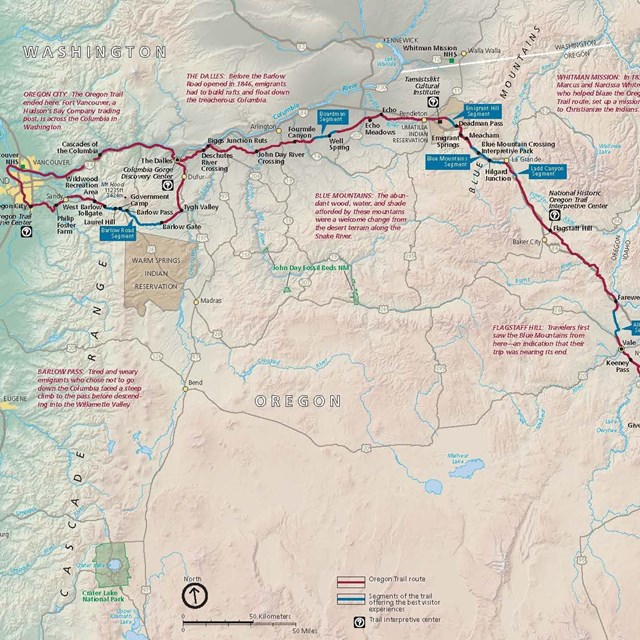
National Park Service LogoU.S. Department of the InteriorNational Park ServiceNational Park Service
National Park Service:  U.S. Department of the InteriorNational Park Service Arrowhead
Oregon National Historic TrailWillamette River Falls at Oregon City, Oregon - end of the Oregon Trail
view map
text size:largestlargernormal
printer friendly
Oregon National Historic Trail
Operating Hours & Seasons
Photo image of Independence Rock and emigrant wagons.

Kay Threlkeld

Photo image of Independence Rock and emigrant wagons.

Local brochures and guides are generally available at each trail site. An Auto Tour Route Interpretive Guide, in Acrobat Reader PDF format, can be downloaded for each of the eight states that the trail passes through. These interpretive guides are currently in development, but the Western Missouri and Northeastern Kansas and the Nebraska and Northeastern Colorado regions are available now in travel and tourism, museum and interpretive centers through these states. The "Auto Tour Route" link will provide state by state driving directions that approximate the historic route of the "Road to Oregon."

Please respect private property by staying in public areas, and help protect our national heritage by leaving trail resources undisturbed.


Trail Partners & Tourism Information Resources:

Oregon & California Trails Association


Bubbling, carbonated waters of Soda Springs, Idaho.  

Did You Know?
Sulphur Springs, near the community of Soda Springs, Idaho, intirgued many Oregon and California bound emigrants. Numerous diaries and journals note the bubbling soda waters and thermal pools - curiosities never before seen by most who passed this way in the 1840s-1860s.
more...

Last Updated: November 01, 2006 at 17:13 EST