|
Regardless of the time of year, every season offers its own special rewards to those who take the time to explore the Obed Wild and Scenic River on foot. Lilly Bluff TrailsThe four trails found in the Lilly Bluff area allow visitors to expore Obed's sun-baked bluffs, sheer cliffs, moisture-rich forests, cascading creeks, and expansive boulder fields.

NPS Photo Overlook TrailDistance: 0.3-mile one wayDifficulty: Easy Enjoy the high rock outcrop of Lilly Bluff, where you’ll find sweeping views of the river gorge. Strollers and wheelchairs can negotiate the gravel trail and boardwalk with minimal assistance. 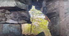
NPS Photo Point TrailDistance: 3.8-mile round-tripDifficulty: Moderate to Strenuous The trail dips to Melton Mill Branch, which can be a trickle in summer or a roar in winter and spring, then leads past a hidden natural arch, guiding you along the bluff to a secluded view overlooking the river gorge. 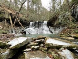
NPS Photo Bridge TrailDistance: 0.5 mile one wayDifficulty: Moderate to Strenuous The trail runs between Lily Bridge and the Overlook trail. It cuts beneath Lilly Bluff, where sheer cliffs are exposed. It lends you low past the trunks of sycamore and ash trees near the river’s edge, then high among hemlock, oak, and hickory canopies. 
NPS Photo Boulder Field TrailDistance: 0.4 mile round tripDifficulty: Easy The trail meanders among massive sandstone boulders, which fell from the bluff thousands of years ago. Today climbers train and test their skill on the boulders’ faces while non-climbers look on. Nemo TrailsThis day use area offers the perfect natural and historic backdrop for your next picnic, forested hiking adventure, or refreshing dip in the river! Do you want to experience Nemo after dark? Pick up a backcountry permit at the visitor center or online!

NPS Photo Emory River Nature TrailDistance: 1.0-mile loop.Difficulty: Easy to Moderate. The Nature Trail shares a small portion of the Cumberland Trail before looping down and around to return along the Emory River to the Rock Creek Campground. The trail offers a close up appreciation of the transition from bluff to gorge, where massive sandstone boulders fell from the bluff thousands of years ago and now rest in and near the river gorge. 
NPS Photo Cumberland Trail – Emory River Gorge SectionDistance: 2.6-mile round-trip.Difficulty: Moderate. Above the Nemo Picnic Area stands the historic Nemo Bridge, now used by hikers to enjoy an above-ground view of the Emory River. The trail leaves the picnic area from the upstream end of the parking lot and ascends above the river to a sweeping overlook of the confluence of the Obed and Emory Rivers. The trail ends at a seasonal stream cascade. 
NPS Photo Cumberland Trail – Obed River SectionDistance: 14.2 miles one way.Difficulty: Very Strenuous. The trail leaves Rock Creek Campground and includes many ascents and descents along the Obed River leading to remote overlooks that offer solitude and sweeping views of the gorge. The section terminus is at the Devils Breakfast Table trailhead. A popular abbreviated hike on this section is from the campground to Alley Ford and back (5 miles roundtrip – moderate to strenuous). For more information on Cumberland Trail State Park, call 423-566-2229. |
Last updated: June 15, 2022
