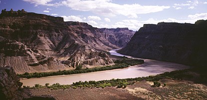
Photo by Mike Hill Ask any ranger or river guide how deep the river is and they’ll probably shrug and say, "Who knows?" Aside from being a common question, it’s a very difficult one to answer accurately. The reason? The Colorado and Green rivers have serpentine channels that change constantly as the current and the sediment it carries act upon each other. Along both rivers, sand bars move continually. Add runoff from storms and spring snowmelt to the mix, and one could argue that few places in the river ever have the same depth for very long. But what’s below all this shifting sediment? The Colorado and Green rivers carry and traverse millions of tons of sand, mud and rocks, but at some point their channels must encounter bedrock. At what depth? Scientists studying this question in Cataract Canyon have found some unexpected answers. Cataract Canyon contains roughly 14 miles of closely spaced, large rapids. These noise makers stand in stark contrast to the calmer conditions upstream on both the Green and Colorado rivers. Glen Canyon, below Cataract, was also known as a leisurely stretch of water before it filled with the waters of Lake Powell. So Cataract Canyon interrupts an otherwise continuous calm with large and treacherous hydraulics. The rapids of Cataract Canyon are created by very large boulders. Some of the most famous are Capsize Rock, which captures the unwary in Rapid 15, and Niagara Rock in Big Drop Two, which forms a fierce hole during high water. None of the rapids in Cataract Canyon are directly affected by bedrock beneath the river. Instead, water is flowing over a mantle of large boulders. Most of these boulders were placed in the river by debris flows from side canyons. Like concrete flowing from a cement mixer, debris flows are slurries of sediment and water, with sediment making up more than 80% of the mix. But on this scale, flows have enough energy to move house-sized boulders. Although isolated rock falls affect the river on occasion, debris flows are the most common process for forming and maintaining rapids. In 1921, the U.S. Geological Survey (USGS) sent a research expedition through Cataract Canyon to locate potential dam sites for water storage and hydroelectric power generation. To evaluate the sites and estimate the volume of water that could be stored in a reservoir, they surveyed the first longitudinal profile of the river. Today we have a complete longitudinal profile of the Colorado River from its headwaters in Colorado to the Gulf of California. In 2003, a USGS team resurveyed the 1921 Cataract Canyon profile and measured changes in the fall of various rapids. Results from this work show that the profile of the river through Cataract Canyon forms a "bulge" or "convexity" in the overall profile of the river. This bulge is the largest on the river and suggests that bedrock is far beneath the surface. Using seismic refraction, scientists evaluated the depth to bedrock in several locations. This method involves transmitting sound waves into the ground and measuring the returning waves. At Spanish Bottom, near the head of the Cataract Canyon convexity, bedrock was found to be 260 feet below the water’s surface. Conventional wisdom holds that rivers constantly erode the land over which they flow. In Cataract Canyon, this doesn’t appear to be the case. Due to debris flows from side canyons, the river may be rising. In fact, Cataract Canyon may be one of the most actively filling canyons in the world. The USGS will continue this work in the coming years. Their results may very well change our understanding of local rivers and the natural processes which guide their evolution. |
Last updated: February 24, 2015