Paddling

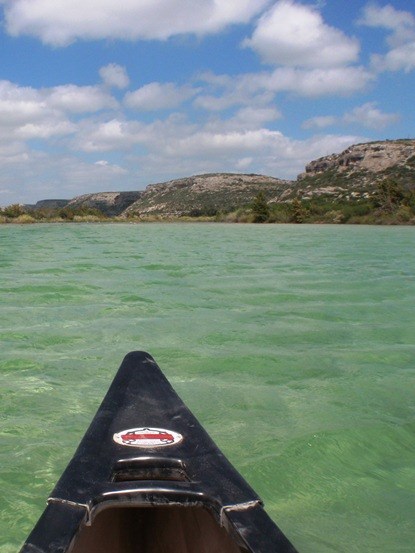
Nose of a kayak with waters of Amistad reservoir in front.
Paddling the Devils River near Pafford Crossing.

NPS Photo

Amistad Reservoir has plenty of wide-open water, as well as steep-walled river canyons, making it a great place for paddling a kayak or canoe. The following routes are suggestions only; they are not marked on shore or in the water.

Be Prepared: Bring plenty of drinking water and salty snacks, a wide-brimmed hat for shade, sunglasses, sun protection, a long-sleeved shirt, and pants. Please be environmentally conscientious and pack out all of your trash. Glass containers are prohibited in the park. Remember that all things living and nonliving are protected under federal law. Take only pictures; leave only footprints.

Remember: Cell phone coverage is very limited. Also, Park Rangers cannot respond for assistance if you get stranded on the Mexico side of the reservoir.

Winds typically average 15-20 mph (19-32 km/hr), but 20-30 mph (32-48 km/hr) winds are not uncommon. Winds are typically from the south or southeast; however, north winds can occur (especially in the fall and winter), but usually do not last more than a day or so. Visit our Current Conditions page for information and links to current water levels, river flow estimates, and weather forecasts.


Paddle Trails
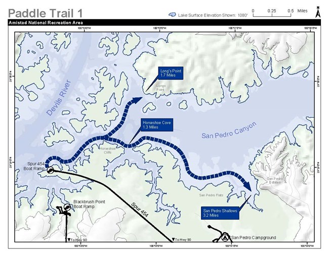
 
Simple map of San Pedro Canyon area. Black Brush and Spur 454 boat ramps shown in the SW corner. Paddle trail goes east from Spur 454 boat ramp, past Horseshoe Cliffs at the 1.3-mile mark, and ends at San Pedro Shallows at the 3.2-mile mark.
Spur 454 to San Pedro Creek

NPS Image

Paddle Trail #1- Spur 454 to San Pedro Creek
This area is an excellent day trip. Put in at Spur 454 and paddle east. There are numerous coves to explore, picnic, or swim. (Please note that putting in at the Black Brush boat ramp is another option and adds about 1 to 1.5 miles, or 1.6-2.4 km, to the total trip.)

Text Description of Map: A simplified map of the San Pedro Canyon area. Black Brush and Spur 454 boat ramps are shown in the southwest corner of the map. The paddle trail goes east from the Spur 454 boat ramp, passes Horseshoe Cliffs at the 1.3-mile (2 km) mark and ends at San Pedro Shallows and the 3.2-mile (5 km) mark. Near Horseshoe Cliffs is a branch split that makes an open water crossing to Longs Point at 1.7 miles (2.7 km). The lake surface elevation used for the map is 1080 feet (329 meters).

 
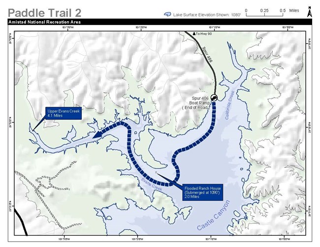
Map of Castle Canyon area. Trail starts at Spur 406 boat ramp near California Creek. Then heads west toward Evans Creek passing the Flooded Ranch House (submerged at 1090-foot lake level) at the 2-mile mark. Trail ends at Upper Evans Creek at 4.1 miles.
Spur 406 to Evans Creek

NPS Image

Paddle Trail #2- Spur 406 to Evans Creek
This area is an excellent day trip, especially when strong south or southeast winds are present. Put in at Spur 406. This area offers excellent birding and is much like Spur 454.

Text Description of Map: A simple map of the Castle Canyon area. The trail starts at the Spur 406 boat ramp near California Creek. The trail then heads west toward Evans Creek passing the Flooded Ranch House (submerged at 1090-foot/332-meter lake level) at the 2-mile (321-kilometer) mark. The trail ends at Upper Evans Creek at 4.1 miles (6.6 kilometers). The lake surface elevation used in the map is 1080 feet (329 meters).

 
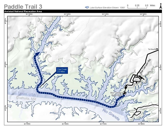
Map of a section of the Rio Grande arm of Amistad Reservoir. Trail starts at Box Canyon boat ramp and heads west 2.5 miles to Cow Creek. Then heads north up Cow Creek as far as the paddler wishes to go.
Box Canyon to Cow Creek

NPS Image

Paddle Trail #3- Box Canyon to Cow Creek
This is a nice daytrip with excellent backcountry camping possibilities. Put in at the Box Canyon ramp and paddle upriver about 2.5 miles (4 kilometers) to Cow Creek. This area offers unique scenery with vertical cliffs and excellent fishing.

Text Description of Map: Map of a section of the Rio Grande arm of Amistad Reservoir. Trail starts at Box Canyon boat ramp and heads west 2.5 miles (4 kilometers) to Cow Creek. Then heads north up Cow Creek as far as the paddler wishes to go.

 
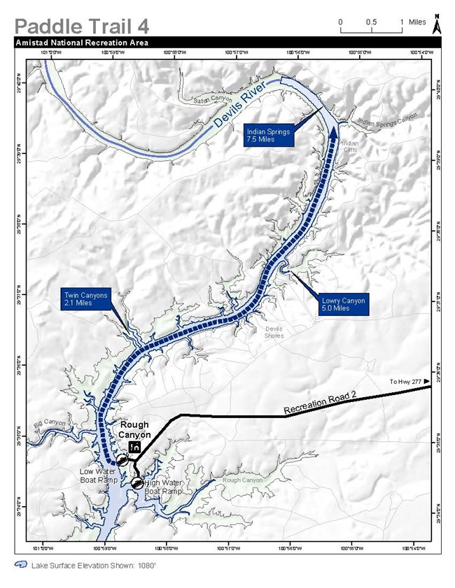
Map of the Devils River arm of the reservoir. Trail starts at Rough Canyon boat ramp and heads north up Devils River. Twin Canyons is noted at the 2.1-mile mark, Lowry Canyon at 5 miles, and Indian Springs at 7.5 miles.
Rough Canyon to Indian Springs

NPS Image

Paddle Trail #4- Rough Canyon to Indian Springs

A 16-mile (25.7-kilometer), round-trip paddle with frequent strong head winds on the return, so best enjoyed as an overnight trip. Put in at the Rough Canyon boat ramp and head upriver 8 miles (12.9 kilometers) to Indian Springs. There are excellent places to camp on the right (east) before you get to the springs and also to the left (west) under the trees. The springs come right out of the rock just beyond Indian Springs Canyon. The water is clear and cold and millions of gallons cascade down the rocky cliffs into pools before they reach the lake.

Text Description of Map: Map of the Devils River arm of the reservoir. Trail starts at Rough Canyon boat ramp and heads north up Devils River. Twin Canyons is noted at the 2.1-mile (3.4-kilometer) mark, Lowry Canyon at 5 miles (3 kilomters), and Indian Springs at 7.5 miles (12 kilometers). The Rough Canyon boat launch is accessed at Recreation Road 2 and Highway 277 from the east.


Paddle Trail #5- Pecos to Parida Cave

This trip is short but provides a good opportunity to experience both scenic canyons and 4,000 year-old Native American rock art. Put in at the Pecos boat ramp and head downriver to the confluence with the Rio Grande. Continue downriver (left) on the Rio Grande until you see a large rock shelter with a courtesy boat dock. Parida Canyon (a noticeably large canyon) is opposite the shelter on the Mexican side of the Rio Grande.


Paddle Trail #6- Pecos to Panther Cave

Follows Paddle Route #5 but continues downriver from Parida Cave for a distance of about 8 miles (13 kilometers) from the Pecos boat launch. Panther Cave is one of the best-preserved, Lower Pecos River style, rock art sites. Due to the distance, lack of good campsites, and frequent strong winds funneling through the canyons, this trip is recommended only for experienced, strong paddlers.


Paddle Trail #7- Pecos to Pecos Railroad Bridge

Approximately 6 miles (10 kilometers) upriver from the Pecos boat ramp is the Pecos railroad bridge, also known as the "High Bridge." Paddling this part of the Pecos River is an excellent daytrip. The tall, scenic limestone cliffs surround you, while offering side canyons to explore and wildlife watching opportunities. Birding is especially good all seasons.

Stopping underneath the High Bridge and waiting for trains to go overhead can be an exciting highlight of this trip. Next, paddle a short way upriver from the bridge and look river left for remnants of an old pump house. Here water was pumped up from the river to a water tank used by the old steam engines during the late 1800s. You might be able to see the concrete pilings of the old, rickety steel bridge of the 1890s on either side of the river near the pump house.

If you want to make the trip longer and camp out, the Pecos offers breathtaking scenery upriver to Dead Mans Canyon and ultimately to Shumla Bend at the end of the park boundary 14 miles (23 kilometers) from the confluence of the Rio Grande. It can be done in one day (if you are an experienced paddler) but is best enjoyed when you have several days to explore the beauty the Pecos River offers. The fishing is good, too.


Devils River Trip- Bakers Crossing to Rough Canyon

This 47.7-mile (76.8-kilometer) trip is suitable only for experienced paddlers, who are prepared to spend at least three days on the river. The trip starts from SH 163 at Bakers Crossing (paddler access via TPWD right-of-way) and continues to Rough Canyon. Paddlers enter Amistad National Recreation Area near Pafford Crossing (river mile 33). Take-out is on Lake Amistad at Rough Canyon (beyond river mile 47). Caution is advised beyond river mile 36 as strong head winds, choppy lake water, and motorized boat traffic may exist.

For more detailed information on this trip, visit Texas Parks & Wildlife Department's Devils River State Natural Area- Preparing for a Devils River Trip page.

Last updated: February 1, 2024

Park footer

Contact Info

Mailing Address:

10477 Highway 90 West
Del Rio, TX 78840

Phone:

(830) 775-7491

Contact Us